6.5.07

Welcome to Vänner Hike

Here you will find the 2007 hiking schedule built for your summer weekend escapes from Calgary (or else where) into the Rocky Mountains! Every Wednesday prior to the hike, group members are asked to confirm their participation to Claire (who will prompt you for your replies).

There is flexibility to swap hikes from Saturdays to Sundays or vice versa. We can even change the weekends if there is enough interest. The idea of setting a schedule was to facilitate more participation as summers get jam packed with extra-circular activities super fast (not to mention weddings). Hopefully if we can get thirty or more people participating there will always a group of friends heading out to the mountains. Due to the number of hike suggestions, there are often two options available. The final destination will be selected closer to the departure date, as well car pooling arrangements.

These hikes are family friendly. A number of members have small - and large children - who are always welcome to come. I am hoping we can even set up some multi-family child care arrangements to allow some of the new mom’s and dad’s a chance to get out. Everyone one is welcome to invite their fellow friends and family members.

The season will be kicked off with a pot lock at Erica’s house in the SW. Details will follow shortly.

I hope everyone on the distribution lists gets out at least once with the group this 2007 season.

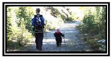
Special thanks to Dave, Kirsty and Erica for their assistance on the schedule.

Cheers,

Claire, Vänner Hike Coordinator

1.5.07

Vänner Hiking Schedule 2007

Click on schedules for larger images.


Citadel Pass

Citadel Pass

Distance: 18.6 km round trip
Elevation: 195 m
Duration: ?
Difficulty: easy to moderate
Access:
From Sunshine Village

The last Sunshine Village’s shuttle bus leaves at 5:00 p.m. — not quite enough time to hike to Citadel Pass and back unless you’re fast and healthy. Which is a real pity, because this trail is fantastic stuff, and you don’t want to turn around any sooner than you have to, and you don’t want to rush.

Other than the climb up and down Quartz Hill in the middle, it’s relatively level going across endless alpine meadows along the continental divide. You cross the border twice before the pass, and you don’t even realize it unless you’re checking your topo map, or you meet a B.C. provincial parks ranger and suddenly realize you’re not in Banff National Park any more.

The trail to Citadel Pass is the first third of the route to Mount Assiniboine, and you get a great view of that peak from the pass. (text credit: http://www.mcwetboy.com/trails/citadel_pass.php).


Buller Pass

Buller Pass

Distance: 6.5 km to pass
Elevation: 671 m
Duration: 4 to 5 hours for Buller Pass, 7 to 8 hours for unnamed summit
Difficulty: Easy to Buller Pass, challenging to unnamed summit
Access: From access from Smith Dorian-Spray Trail

This is a lovely trail that gives you a taste of everything a mountain hike has to offer. The trail starts out in fairly thick forest, on a gentle elevation. As the trail progresses the slope increases into a fairly long uphill climb to the alpine meadow, passing a nice waterfall on the way. Once you reach the meadow, it is about a 2km fairly flat hike to the actual pass, in which you'll rise above the tree line. The pass itself is very steep, but the view the top is well worth the climb. When all is said and done, you'll have gained over 650m elevation from the parking lot.

To to top of the pass is approx. 6.5 kms one way. You can continue from the top of the pass, down the backside to Ribbon Lake, which is another 4km. This may be tough to complete on a day hike for a beginner, as you'll have to overcome the pass again on the way back. However, Ribbon Lake is home to a nice back country campground, and this hike offers a nice alternative to the "chains" of the Ribbon Creek trail (text credit: http://www.trailpeak.com/index.jsp?cat=hike&con=trail&val=1899).

Rockbound Lake

Rockbound Lake

Distance: 6.5 km to pass
Elevation: 671m
Duration: 2 to 3 hours one way
Difficulty:

Access: Off bow valley parkway - towards Lake Louise - behind Castle Mountain

Nestled beneath the colossal ramparts of Castle Mountain, Rockbound Lake is part of an elemental landscape of water, rock and sky, inspiring in its simplicity. Wildflower displays, larches, intriguing geology, and human history add interest to this outing.

This is a rigorous outing to a high valley hidden behind the ramparts of Castle Mountain and two distinctly different lakes: one a placid, green mirror fringed by open subalpine forest and lush wildflower meadows; the other a cold, grey sheet contained by steep talus slopes and massive, tumbled boulder fields. Both lakes are overshadowed by the impressive Eisenhower Peak tower and the limestone cliffs of Castle Mountain. On the way back, we will take the short side-trip to Silverton Falls, as the falls are typically shaded in the early morning (text credit: http://www.calgaryoutdoorclub.com/events/details.asp?eventid=1077).

Bourgeau Lake to Harvey Pass

Bourgeau Lake to Harvey Pass

Distance: 7.5 km to lake/9.7 km to pass
Elevation: 725 m elevation gain to lake/1025 m elevation gain to pass
Duration: 2.5-3.5 hours one way
Difficulty: difficult

Access: From the Trans-Canada approx 2 km from Sunshine turnoff, very steep at end

This 7.5-km trail climbs the slopes of Mt. Bourgeau to a small alpine lake nestled high above the Bow Valley. The path follows the course of Wolverine Creek, which delivers the outflow of Bourgeau Lake into the Bow River. A climb of 725m is required to reach the lake, which is a lovely setting for a picnic before retracing your route back down to the trailhead (text credit: http://www.trailpeak.com/index.jsp?cat=hike&con=trail&val=1837).

Tumbling Glacier


Tumbling Glacier

Distance: 10.6 km one way, 7.5 km to lake/9.7 km to pass
Elevation: 760 m
Duration: 4 hours to pass
Difficulty: difficult

Access: From the access from Hwy 93 (Banff-Radium) at Paint Pots Parking Lot in Kootenay National Park, hiking through Columbian Rainforest


Yoho Burgess Shale

Yoho Burgess Shale

Distance: 9.2 km one way
Elevation: 290 m
Duration: 3.5 hours one way
Access:

Journey to Yoho Valley for spectacular views of Takkakkaw falls, lakes, and glaciers. Guided by geologists. Lots of Fossils. Erica knows several people who guide there. More information will be posted later.

Larch Valley

Larch Valley

Distance: 5.8 km to pass
Elevation: 724 m
Duration: 2 h to Sentinel Pass
Difficulty: easy to moderate

Access: access from Moraine Lake, MUST be in groups of 6 or more – they checked us last year and fined people who weren’t in groups of six

The hike to Larch Valley ranks as one of the more popular outings in Banff National Park, especially in autumn when the subalpine larches display a radiant golden glow. (This trail can be crowded in the fall, particularly on weekends--other good areas for the colour of the larches turning are the meadows above Taylor Lake and the slopes around Boulder Pass.)

Arrival at Larch Valley is a reward well-earned, since you climb 550 metres in just 4.2 km. After the series of steady switchbacks up from Moraine Lake, you might enjoy a pause on the rest bench at the junction with the Eiffel Lake trail.

Keeping right for Larch Valley, the first stands of larch soon appear, then you come to a fair-sized meadow. Mt. Temple rises loftily to the north, while ahead stand Pinnacle Mtn. and Eiffel Peak--named for a rock tower on its north side (not visible from this trail) that resembles the famous landmark in Paris.

After a level section through the meadow, the path leads up steadily--although more gently than the trail up from Moraine Lake--to pass the last trees at approximately km 3.7. Five hundred metres further on, you reach the shore of the largest of the Minnestimma Lakes nestled in the bowl between Mt. Temple and Pinnacle Mtn. The name of these small tarns has the evocative meaning "sleeping water." It was bestowed by early explorer/mountaineer Samuel Allen, who had the assistance of Stoney Indian William Twin in choosing the many names from their language that he conferred on features.

Of Allen's original Stoney-numeral names for the summits on the south south of the Valley of the Ten Peaks, only those for Neptuak (nine) and Wenkchemna (ten) survive. The others have been renamed for non-Natives; one of them (Peak Six) honours Allen himself (http://www.canadianrockies.net/luminous/mplarch.html).

Jasper Hike and Camping

Jasper Hike and Camp Weekend

Wilcox Pass – Stretch Your Legs on Way to Jasper
Distance:
12 km return
Elevation: 335 m
Duration: 2.5 hours return
Difficulty: easy

Access: The hike is at the southern end of the Park, close to the boundary of Banff National Park. It is close to the midway point of the Icefields Parkway (Hwy 93), 127 km north of Lake Louise and 106 km south of Jasper. Trailhead: Wilcox Creek. Turn off the Icefields Parkway 3 km south of the Icefield Center (on the right as you travel north, left as you head south). There is a small parking area on the left, a short way along this campground access road.


This would be a good one for the journey up to Jasper. It's in the Columbia Icefields, is relatively easy and short, and according to my book is 'instantly gratifying'.

This hike is one of those “I can’t believe you get all of this for so little effort”. After the 20 minute or so climb (1-1/2K) to the valley it’s all yours. Views of the Columbia Icefields and many mountain peaks abound including a huge view of
Athabasca Mountain and Glacier. After the first 20-30 minutes it’s all flat and beautiful. The other bonus is the lack of any real destination. You can hike a long way or a short way its up to you. If you turn around half way to the actual pass or if you go beyond it you won’t miss anything. We just went to the pass but apparently there is a loop that takes you back to the Icefields Parkway. We decided not to do this because you must either walk or hitchhike about 7 kilometers back to your car once you reach the highway. We agreed it made more sense to walk back from whence we came and enjoy the splendor of the views from the opposite direction. This beautiful little hike offers hikers the opportunity of experiencing real back country Rocky Mountain hiking with a fraction of the effort normally required for these views. Along the way we encountered a herd of about a dozen Rocky Mountain Long Horn Sheep the hikers in front of us were so close to them they could have touched them. They actually got between some of them. The animals seemed somewhat uninterested by our presence but it was quite exciting for us hikers to be in such close proximity to these beautiful animals. There are a few herds that apparently inhabit this valley and your chances of seeing them as we did are very good.

My wife and I travel many kilometers up and down many mountain moraines to find the very landscape we found ourselves in within 30 minutes of moderate climbing. You can judge for yourself by the content of the pictures I’ve attached. Even experienced hikers will enjoy this easy hike. Put it on your list of hikes to do in the Rockies (http://www.trailpeak.com/index.jsp?cat=hike&con=trail&val=1280).

Link: http://www.onedayhikes.com/Hikes.asp?HikesID=132

Jasper Weekend Camping and Hikes to be determined