Distance: 6.5 km to pass
Elevation: 671 m
Duration: 4 to 5 hours for
Difficulty: Easy to
Access: From access from Smith Dorian-Spray Trail
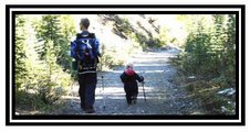
This is a lovely trail that gives you a taste of everything a mountain hike has to offer. The trail starts out in fairly thick forest, on a gentle elevation. As the trail progresses the slope increases into a fairly long uphill climb to the alpine meadow, passing a nice waterfall on the way. Once you reach the meadow, it is about a 2km fairly flat hike to the actual pass, in which you'll rise above the tree line. The pass itself is very steep, but the view the top is well worth the climb. When all is said and done, you'll have gained over 650m elevation from the parking lot.
To to top of the pass is approx. 6.5 kms one way. You can continue from the top of the pass, down the backside to

No comments:
Post a Comment